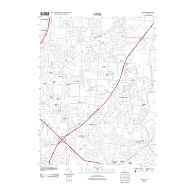
2010 Map of Mason
USGS Topo · Published 2010About this map
Mason and Loveland anchor this detailed study of the suburbanizing corridor north of Cincinnati, where legacy family landmarks meet modern expansion. The landscape is defined by the Little Miami River along the eastern border, while historic waypoint settlements like Sixteen Mile Stand and Twenty Mile Stand mark the old coaching routes. Residential growth is evident in dozens of named neighborhoods such as Socialville, Miltomson, and Wetherington, interspersed with recreational sites like the Western Row Golf Course and Kingswood Golf Course.
Find a feature on this map
100 named features on this map. Tap any name to fly to it.
Don’t see what you’re looking for? This feature index may not catch every label — zoom into the map to look around manually.
Map Details
Editions of this 2010 Mason Map
This is the sole edition of this map. No revisions or reprints were ever made.
Other maps of this area

1898 · East Cincinnati
USGS Topo · 1:62,500

1904 · Mason
USGS Topo · 1:62,500

1906 · Mason
USGS Topo · 1:62,500

1914 · East Cincinnati
USGS Topo · 1:62,500

1914 · Batavia
USGS Topo · 1:48,000

1914 · Morrow
USGS Topo · 1:62,500

1916 · Batavia
USGS Topo · 1:62,500

1916 · Morrow
USGS Topo · 1:62,500

1953 · Goshen
USGS Topo · 1:24,000
1953 · Madeira
USGS Topo · 1:24,000