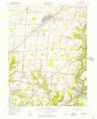
1955 Map of Mason
USGS Topo · Published 1956About this map
The U S Government Reservation (Voice of America) and its sprawling complex of radio towers dominates the northwestern portion of this mid-1950s survey. This landscape at the intersection of Butler, Warren, Hamilton, and Clermont counties is a mix of developing suburbs and established rural villages. The Little Miami River carves a deep valley along the eastern boundary, serving as a corridor for the Pennsylvania railroad and supporting industrial sites like Kings Mills.
Find a feature on this map
80 named features on this map. Tap any name to fly to it.
Don’t see what you’re looking for? This feature index may not catch every label — zoom into the map to look around manually.
Map Details
Editions of this 1955 Mason Map
This is the sole edition of this map. No revisions or reprints were ever made.
Other maps of this area

1898 · East Cincinnati
USGS Topo · 1:62,500

1904 · Mason
USGS Topo · 1:62,500

1906 · Mason
USGS Topo · 1:62,500

1914 · East Cincinnati
USGS Topo · 1:62,500

1914 · Batavia
USGS Topo · 1:48,000

1914 · Morrow
USGS Topo · 1:62,500

1916 · Batavia
USGS Topo · 1:62,500

1916 · Morrow
USGS Topo · 1:62,500

1953 · Goshen
USGS Topo · 1:24,000
1953 · Madeira
USGS Topo · 1:24,000