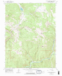
1967 Map of Matchless Mountain
USGS Topo · Published 1988About this map
Gunnison National Forest dominates this mid-century survey, revealing a landscape defined by resource extraction and recreational expansion within the high country. The topography is etched by steep gulches and prominent summits like Boston Peak and Matchless Mountain. At the heart of the district, the Doctor Mine and other unnamed mine sites indicate the area's geological value, while the presence of the Matchless Trail suggests the persistence of older pack routes alongside more modern developments.
Find a feature on this map
39 named features on this map. Tap any name to fly to it.
Don’t see what you’re looking for? This feature index may not catch every label — zoom into the map to look around manually.
Map Details
Editions of this 1967 Matchless Mountain Map
4 editions found
Other maps of this area

1888 · Crested Butte
USGS Topo · 1:62,500

1889 · Crested Butte
USGS Topo · 1:62,500

1893 · Crested Butte
USGS Topo · 1:62,500

1934 · Taylor Park
USGS Topo · 1:62,500

1937 · Taylor Park
USGS Topo · 1:62,500

1941 · Pitkin
USGS Topo · 1:62,500

1945 · Pitkin
USGS Topo · 1:62,500

1956 · Montrose
USGS Topo · 1:250,000

1959 · Montrose
USGS Topo · 1:250,000

1960 · Montrose
USGS Topo · 1:250,000