
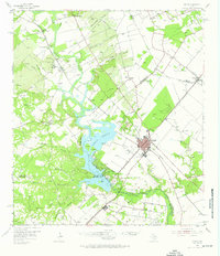
1954 Map of Mathis
USGS Topo · Published 1956About this map
The Nueces River forms a sprawling waterway in this mid-century survey, pooling into the northern reaches of Corpus Christi Lake. This hydraulic landscape is defined by the intersection of water management and petroleum extraction, with the Lake Corpus Christi State Park occupying the western shoreline while the Wilman Oil Field and Ganda Oil Field pockmark the surrounding plains. The town of Mathis serves as the regional hub, situated at the junction of the Missouri Pacific and Texas and New Orleans railroads.
Find a feature on this map
75 named features on this map. Tap any name to fly to it.
Don’t see what you’re looking for? This feature index may not catch every label — zoom into the map to look around manually.
Map Details
Editions of this 1954 Mathis Map
2 editions found
Other maps of this area

1920 · Mikeska
USGS Topo · 1:125,000

1920 · San Diego
USGS Topo · 1:62,500

1925 · Oakville No. 4
USGS Topo · 1:48,000

1925 · Mathis No. 2
USGS Topo · 1:48,000

1925 · Robstown
USGS Topo · 1:62,500

1925 · Mathis No. 3
USGS Topo · 1:48,000

1927 · Mathis
USGS Topo · 1:62,500

1927 · Oakville
USGS Topo · 1:62,500

1950 · Corpus Christi
USGS Topo · 1:250,000

1953 · Crystal City
USGS Topo · 1:250,000