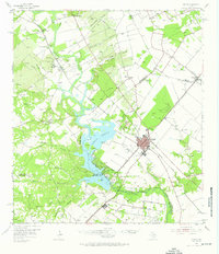
1954 Map of Mathis
USGS Topo · Published 1976About this map
The Nueces River valley defines this mid-century landscape, dominated by the waters of Corpus Christi Lake and the industrial activity of the South Texas oil fields. At the center of the regional rail network, Mathis serves as a hub where the Missouri Pacific and the Texas and New Orleans railroads converge. The surrounding territory is deeply marked by petroleum exploration, featuring the Mt Lucas Oil Field, Wilman Oil Field, and Sandia Oil Field. Away from the main settlements, a network of family-named landmarks and rural outposts like Swinney Switch and Dinero provide a glimpse into the area's social geography. Local history is preserved in numerous burial grounds, including the Old Casa Blanca Cem and the Lagarto Cem, while the Lake Corpus Christi State Park offers a look at the transition from rugged river breaks to managed recreation.
Find a feature on this map
69 named features on this map. Tap any name to fly to it.
Don’t see what you’re looking for? This feature index may not catch every label — zoom into the map to look around manually.
Map Details
Editions of this 1954 Mathis Map
2 editions found

Other maps of this area

1920 · Mikeska
USGS Topo · 1:125,000

1920 · San Diego
USGS Topo · 1:62,500

1925 · Oakville No. 4
USGS Topo · 1:48,000

1925 · Mathis No. 2
USGS Topo · 1:48,000

1925 · Robstown
USGS Topo · 1:62,500

1925 · Mathis No. 3
USGS Topo · 1:48,000

1927 · Mathis
USGS Topo · 1:62,500

1927 · Oakville
USGS Topo · 1:62,500

1950 · Corpus Christi
USGS Topo · 1:250,000

1953 · Crystal City
USGS Topo · 1:250,000