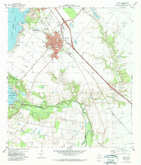
1979 Map of Mathis
USGS Topo · Published 1979About this map
The city of Mathis serves as a regional hub at the convergence of the Missouri Pacific and Southern Pacific railroads during the late 1970s. The landscape is defined by the managed waters of the Nueces River, held back by the Seale Dam to form the expansive Lake Corpus Christi. This intersection of rail transit and water management supported both the local agricultural economy and growing recreational interests at Lake Corpus Christi State Park.
Find a feature on this map
32 named features on this map. Tap any name to fly to it.
Don’t see what you’re looking for? This feature index may not catch every label — zoom into the map to look around manually.
Map Details
Editions of this 1979 Mathis Map
This is the sole edition of this map. No revisions or reprints were ever made.
Other maps of this area

1925 · Mathis No. 2
USGS Topo · 1:48,000

1925 · Robstown
USGS Topo · 1:62,500

1925 · Mathis No. 3
USGS Topo · 1:48,000

1927 · Mathis
USGS Topo · 1:62,500

1950 · Corpus Christi
USGS Topo · 1:250,000

1953 · Beeville
USGS Topo · 1:250,000

1954 · Orange Grove
USGS Topo · 1:62,500

1954 · Robstown
USGS Topo · 1:62,500

1954 · Mathis
USGS Topo · 1:62,500

1954 · Sinton
USGS Topo · 1:62,500