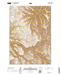
2020 Map of Matney Flat
USGS Topo · Published 2020About this map
Matney Flat anchors this high-elevation landscape in Gilliam County, where the plateau is deeply incised by a network of drainage systems. The northern reaches are defined by Sixmile Cr and several named ravines, including Monahan Canyon and Carnine Canyon. Historical land use is evidenced by the Old Railroad Grade in the northwest, suggesting former transport routes through this dissected terrain.
Find a feature on this map
33 named features on this map. Tap any name to fly to it.
Don’t see what you’re looking for? This feature index may not catch every label — zoom into the map to look around manually.
Map Details
Editions of this 2020 Matney Flat Map
This is the sole edition of this map. No revisions or reprints were ever made.
Other maps of this area

1916 · Condon
USGS Topo · 1:125,000

1953 · Pendleton
USGS Topo · 1:250,000

1953 · The Dalles
USGS Topo · 1:250,000

1956 · The Dalles
USGS Topo · 1:250,000

1956 · Pendleton
USGS Topo · 1:250,000

1957 · The Dalles
USGS Topo · 1:250,000

1968 · Gooseberry
USGS Topo · 1:24,000
1969 · Lonerock
USGS Topo · 1:24,000

1970 · Condon
USGS Topo · 1:24,000
1970 · Salmon Fork
USGS Topo · 1:24,000