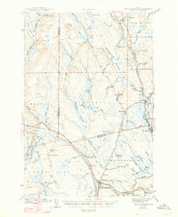
1942 Map of Mattawamkeag
USGS Topo · Published 1947About this map
The confluence of the Penobscot River and the Mattaseunk Stream anchors this interior Maine landscape, where logging and transit defined local life in the early 1940s. Two major rail lines, the Maine Central and the Canadian Pacific, converge at the village of Mattawamkeag, illustrating the town's importance as a transportation junction. To the north and west, the terrain is characterized by a network of drainage basins, including the Salmon Stream Lake and the long course of Molunkus Stream.
Find a feature on this map
80 named features on this map. Tap any name to fly to it.
Don’t see what you’re looking for? This feature index may not catch every label — zoom into the map to look around manually.
Map Details
Editions of this 1942 Mattawamkeag Map
3 editions found
Other maps of this area

1920 · Winn
USGS Topo · 1:62,500

1931 · Springfield
USGS Topo · 1:48,000

1934 · Springfield
USGS Topo · 1:62,500

1940 · Sherman
USGS Topo · 1:62,500

1940 · Mattawamkeag
USGS Topo · 1:62,500

1941 · Mattawamkeag Lake
USGS Topo · 1:62,500

1941 · Wytopitlock
USGS Topo · 1:62,500

1942 · Lincoln
USGS Topo · 1:62,500

1942 · Mattawamkeag
USGS Topo · 1:62,500

1942 · Sherman
USGS Topo · 1:62,500