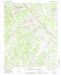
1971 Map of Matthews
USGS Topo · Published 1988About this map
The Seaboard Coast Line corridor anchors the northern development of this region, connecting Matthews and Stallings as the suburban expansion of Charlotte moves eastward. This 1971 survey, updated in the late 1980s, reveals a landscape transitioning from rural crossroads to residential communities. The boundary between Mecklenburg and Union counties splits the sheet, where numerous local churches like Mt Harmony Ch and Hudson Grove Ch served as established community anchors amidst the growing subdivisions. Significant watercourses, including Twelvemile Creek and Fourmile Creek, define the drainage patterns across the rolling terrain. The southern portion of the map remains more open, featuring small settlements such as Weddington and Wesley Chapel, and the infrastructure of the Monroe Airport near the southeastern edge. This record is particularly useful for observing the early stages of rapid urbanization that eventually transformed these formerly quiet farming and rail outposts.
Find a feature on this map
43 named features on this map. Tap any name to fly to it.
Don’t see what you’re looking for? This feature index may not catch every label — zoom into the map to look around manually.
Map Details
Editions of this 1971 Matthews Map
3 editions found
Other maps of this area

1905 · Charlotte
USGS Topo · 1:48,000

1907 · Charlotte
USGS Topo · 1:62,500

1941 · Charlotte
USGS Topo · 1:125,000

1941 · Spartanburg
USGS Topo · 1:250,000

1942 · Charlotte
USGS Topo · 1:125,000

1948 · Charlotte East
USGS Topo · 1:24,000

1949 · Charlotte East
USGS Topo · 1:24,000

1949 · Wilgrove
USGS Topo · 1:24,000

1949 · Midland
USGS Topo · 1:24,000

1953 · Spartanburg
USGS Topo · 1:250,000