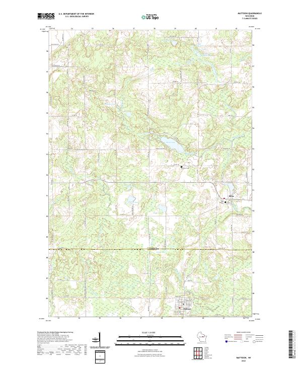
2022 Map of Mattoon
USGS Topo · Published 2022About this map
Mattoon and Phlox anchor this portion of the Northwoods at the boundary of Langlade and Shawano counties. The landscape is defined by a dense network of glacial water bodies, from larger basins like Moose Lake and Dollar Lake to smaller pockets such as Kennedy Lake and Thompson Lake. The Red River and its tributary, the W Br Red River, wind through the terrain, fed by smaller streams like Mayking Creek and Mondl Cr. Genealogists will find notable points of interest at Saint Joseph's Cem and Norwood Cem near the local settlements. The map illustrates a transitional zone where organized town grids meet an irregular hydrologic system, providing a clear view of how early 21st-century road networks like Co Hwy S and Co Hwy D navigate the wetlands and wooded tracts characteristic of this Wisconsin region.
Find a feature on this map
88 named features on this map. Tap any name to fly to it.
Don’t see what you’re looking for? This feature index may not catch every label — zoom into the map to look around manually.
Map Details
Editions of this 2022 Mattoon Map
This is the sole edition of this map. No revisions or reprints were ever made.
Other maps of this area

1952 · Antigo
USGS Topo · 1:48,000

1952 · White Lake
USGS Topo · 1:48,000

1954 · Wittenberg
USGS Topo · 1:48,000

1954 · Gresham
USGS Topo · 1:48,000

1954 · Iron Mountain
USGS Topo · 1:250,000

1955 · Green Bay
USGS Topo · 1:250,000

1959 · Iron Mountain
USGS Topo · 1:250,000

1964 · Wittenberg
USGS Topo · 1:62,500

1964 · Gresham
USGS Topo · 1:62,500
1973 · Antigo
USGS Topo · 1:24,000