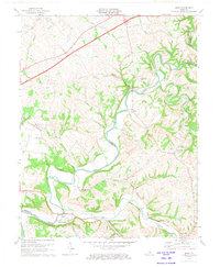
1972 Map of Maud
USGS Topo · Published 1973About this map
The winding Beech Fork river carves a distinct path through the landscape of the Nelson and Washington County border, framing a collection of rural crossroads and river settlements. In the early 1970s, this area retained much of its traditional character, with small communities like Maud, Fredericktown, and Mooresville serving as local anchors. A notable physical landmark is the Covered Bridge spanning the Beech Fork, situated near the tight river bends of Cooney Neck. In the northern portion of the map, the Blue Grass Parkway cuts a modern diagonal across older routes like Stringtown Road and A Lane. Local religious and family history is preserved at sites such as Campground Ch, Walkers Chapel, and the Holy Trinity Cem near Fredericktown, reflecting a deeply rooted community structure oriented around the river and its many tributaries, including Cartwright Creek and Sunfish Creek.
Find a feature on this map
38 named features on this map. Tap any name to fly to it.
Don’t see what you’re looking for? This feature index may not catch every label — zoom into the map to look around manually.
Map Details
Editions of this 1972 Maud Map
2 editions found
Other maps of this area

1952 · Chaplin
USGS Topo · 1:24,000

1953 · Loretto
USGS Topo · 1:24,000

1953 · Brush Grove
USGS Topo · 1:24,000

1953 · Maud
USGS Topo · 1:24,000

1953 · Saint Catharine
USGS Topo · 1:24,000

1953 · Bardstown
USGS Topo · 1:24,000

1953 · Springfield
USGS Topo · 1:24,000

1953 · Bloomfield
USGS Topo · 1:24,000

1953 · Fairfield
USGS Topo · 1:24,000

1957 · Winchester
USGS Topo · 1:250,000