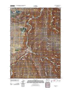
2011 Map of Maupin
USGS Topo · Published 2011About this map
The Deschutes River serves as the central artery for this portion of Wasco County, carved deeply into the high plateau where the high desert meets the river's edge. The town of Maupin is the primary hub, situated where the river makes a pronounced bend, with the neighborhood of East Maupin across the water and the small settlement of Cambrai just to the south. The river's confluence with the White River near Devils Halfacre highlights the complex drainage patterns of the region, where numerous canyons like Stag Canyon and Chicken Spring Canyon feed into the main canyon floor. To the north, the geography transitions into the Tygh Valley, while the eastern side of the river is marked by the meandering paths of Bakeoven Creek and Nye Creek. Smaller, localized names such as Tuskan and Oak Springs suggest older points of activity along the water's edge, linked by narrow corridors like Oak Springs Rd and Deschutes River Rd.
Find a feature on this map
30 named features on this map. Tap any name to fly to it.
Don’t see what you’re looking for? This feature index may not catch every label — zoom into the map to look around manually.
Map Details
Editions of this 2011 Maupin Map
This is the sole edition of this map. No revisions or reprints were ever made.
Other maps of this area

1930 · Dufur
USGS Topo · 1:125,000

1934 · Dufur
USGS Topo · 1:125,000

1953 · The Dalles
USGS Topo · 1:250,000

1956 · The Dalles
USGS Topo · 1:250,000

1957 · The Dalles
USGS Topo · 1:250,000

1962 · Sherars Bridge
USGS Topo · 1:24,000

1962 · Postage Stamp Butte
USGS Topo · 1:24,000
1962 · Dant
USGS Topo · 1:24,000

1962 · Sinamox
USGS Topo · 1:24,000
1962 · Tygh Valley
USGS Topo · 1:24,000