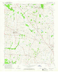
1964 Map of Maury City
USGS Topo · Published 1966About this map
Maury City and the county seat of Alamo anchor this mid-1960s topographic study of the West Tennessee landscape. The Gulf Mobile and Ohio railroad corridor dictates the regional orientation, cutting northwest through the terrain near Maury Junction and Crockett Mills. This era of the landscape is defined by a dense network of local institutions that reflect long-standing rural community centers, including the Hamlett Robertson Sch and numerous country churches like Barkers Chapel, Averys Chapel, and Hughes Grove Ch.
Find a feature on this map
42 named features on this map. Tap any name to fly to it.
Don’t see what you’re looking for? This feature index may not catch every label — zoom into the map to look around manually.
Map Details
Editions of this 1964 Maury City Map
2 editions found
Other maps of this area

1939 · Halls
USGS Topo · 1:62,500

1952 · Bonicord
USGS Topo · 1:24,000

1952 · Chestnut Bluff
USGS Topo · 1:24,000

1956 · Blytheville
USGS Topo · 1:250,000

1959 · Blytheville
USGS Topo · 1:250,000

1959 · Bells
USGS Topo · 1:24,000

1961 · Jones
USGS Topo · 1:24,000

1961 · Halls
USGS Topo · 1:62,500
1964 · Tibbs
USGS Topo · 1:24,000
1964 · Alamo
USGS Topo · 1:24,000