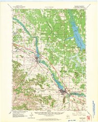
1962 Map of Mauston
USGS Topo · Published 1970About this map
The Lemonweir River and the Castle Rock Flowage dominate this early 1960s landscape of Juneau County, Wisconsin. The terrain is defined by a series of distinctive bluffs and ridges, such as Duckworth Ridge, Townline Bluff, and the unique Steamboat Rock, which stand in contrast to the marshy lowlands and winding river valleys. The rail corridor of the Chicago Milwaukee St Paul and Pacific connects the primary hubs of Mauston and New Lisbon, while the military presence at Volk Field and Camp Williams is firmly established in the northwest.
Find a feature on this map
90 named features on this map. Tap any name to fly to it.
Don’t see what you’re looking for? This feature index may not catch every label — zoom into the map to look around manually.
Map Details
Editions of this 1962 Mauston Map
2 editions found

Other maps of this area

1901 · The Dells
USGS Topo · 1:62,500

1919 · Kendall
USGS Topo · 1:62,500

1921 · Mauston
USGS Topo · 1:62,500

1921 · Kendall
USGS Topo · 1:62,500

1927 · Hillsboro
USGS Topo · 1:62,500

1953 · Eau Claire
USGS Topo · 1:250,000

1955 · Green Bay
USGS Topo · 1:250,000

1956 · Reedsburg
USGS Topo · 1:62,500

1957 · Wisconsin Dells
USGS Topo · 1:62,500

1957 · Madison
USGS Topo · 1:250,000