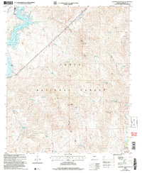
2004 Map of Maverick Mountain
USGS Topo · Published 2007About this map
Tonto National Forest defines the rugged topography of this Maricopa County landscape, where the Verde River meets the Bartlett Reservoir Spillway. The terrain is characterized by a dense network of seasonal water sources and tanks necessary for ranching and wildlife, including Cottonwood Tank and Carlock Tank. Significant landmarks like Maverick Mountain and Cave Creek Mesa rise above numerous drainages such as Maverick Canyon and Indian Springs Canyon.
Find a feature on this map
57 named features on this map. Tap any name to fly to it.
Don’t see what you’re looking for? This feature index may not catch every label — zoom into the map to look around manually.
Map Details
Editions of this 2004 Maverick Mountain Map
This is the sole edition of this map. No revisions or reprints were ever made.
Other maps of this area

1904 · Ft. McDowell
USGS Topo · 1:62,500

1906 · Ft. McDowell
USGS Topo · 1:62,500

1907 · Roosevelt
USGS Topo · 1:125,000

1909 · Four Peaks
USGS Topo · 1:125,000

1912 · Roosevelt
USGS Topo · 1:125,000

1930 · Cave Creek
USGS Topo · 1:125,000

1939 · Cave Creek
USGS Topo · 1:125,000

1954 · Mesa
USGS Topo · 1:250,000

1957 · Mesa
USGS Topo · 1:250,000

1958 · Mesa
USGS Topo · 1:250,000