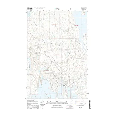
2016 Map of Max
USGS Topo · Published 2016About this map
Chippewa National Forest surrounds the small settlement of Max, anchoring a landscape defined by an intricate network of glacial lakes and managed waterways. This 2016 survey documents the complex hydrology of the region, where the Bowstring River feeds into a series of interconnected basins including Cut Foot Sioux Lake and Little Cut Foot Sioux Lake. The mapping reveals a distinct pattern of land use, with a dense web of recreational and forestry infrastructure such as the Cut Foot Sioux N R T and numerous horse trails winding through the timber. Significant geographic markers like Seelye Point and Battle Point divide the bays of the larger lakes, while artificial structures such as the Amik Impoundment and Twomile Impoundment indicate 20th-century water management efforts. The inclusion of the Avenue of Pines Snowmobile Tr highlights the area's modern role as a hub for seasonal outdoor activity within the national forest system.
Find a feature on this map
55 named features on this map. Tap any name to fly to it.
Don’t see what you’re looking for? This feature index may not catch every label — zoom into the map to look around manually.
Map Details
Editions of this 2016 Max Map
This is the sole edition of this map. No revisions or reprints were ever made.
Other maps of this area

1919 · Max
USGS Topo · 1:62,500

1954 · Bemidji
USGS Topo · 1:250,000

1954 · Hibbing
USGS Topo · 1:250,000

1957 · Bemidji
USGS Topo · 1:250,000

1957 · Hibbing
USGS Topo · 1:250,000

1958 · Bemidji
USGS Topo · 1:250,000

1958 · Hibbing
USGS Topo · 1:250,000

1964 · Hibbing
USGS Topo · 1:250,000

1970 · Bowstring Lake
USGS Topo · 1:24,000
1970 · Little Ball Club Lake
USGS Topo · 1:24,000