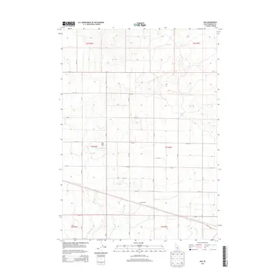
2013 Map of Max
USGS Topo · Published 2013About this map
Max (Historical) centers this grid-patterned landscape of Minidoka County, illustrating the extensive agricultural irrigation network essential to the Snake River Plain. The map reveals an intricate system of man-made waterways, including C Main Drain, D Main Drain, and B Main Drain, which serve the surrounding agricultural sections. This system allowed for the cultivation of the arid high desert, transforming the region into a productive farming district by the early 21st century.
Find a feature on this map
31 named features on this map. Tap any name to fly to it.
Don’t see what you’re looking for? This feature index may not catch every label — zoom into the map to look around manually.
Map Details
Editions of this 2013 Max Map
This is the sole edition of this map. No revisions or reprints were ever made.
Other maps of this area

1954 · Pocatello
USGS Topo · 1:250,000

1958 · Pocatello
USGS Topo · 1:250,000

1959 · Lake Walcott
USGS Topo · 1:62,500

1964 · Rupert NW
USGS Topo · 1:24,000

1964 · Acequia
USGS Topo · 1:24,000

1972 · Community Lake
USGS Topo · 1:24,000

1972 · Minidoka
USGS Topo · 1:24,000

1972 · Max
USGS Topo · 1:24,000
1972 · Norland
USGS Topo · 1:24,000
1972 · Brigham Point
USGS Topo · 1:24,000