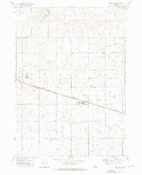
1972 Map of Norland
USGS Topo · Published 1976About this map
The Union Pacific rail line cuts a straight path across this agricultural landscape on the border of Lincoln and Minidoka counties. Small railroad settlements like Adelaide and Norland anchor the corridor, serving as local collection points for the region's produce. The infrastructure of 1970s Idaho farming is evident in the numerous labeled storage facilities, including Storage Bins scattered along the grid-like road network of 1500 North Road and 1300 N Rd.
Find a feature on this map
23 named features on this map. Tap any name to fly to it.
Don’t see what you’re looking for? This feature index may not catch every label — zoom into the map to look around manually.
Map Details
Editions of this 1972 Norland Map
This is the sole edition of this map. No revisions or reprints were ever made.
Other maps of this area

1954 · Pocatello
USGS Topo · 1:250,000

1958 · Pocatello
USGS Topo · 1:250,000

1964 · Burley NE
USGS Topo · 1:24,000

1964 · Rupert NW
USGS Topo · 1:24,000

1964 · Acequia
USGS Topo · 1:24,000

1972 · Shale Butte
USGS Topo · 1:24,000

1972 · Kimama
USGS Topo · 1:24,000

1972 · Community Lake
USGS Topo · 1:24,000

1972 · Max
USGS Topo · 1:24,000
1972 · Larkspur Park
USGS Topo · 1:24,000