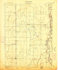
1906 Map of Maxwell
USGS Topo · Published 1913About this map
Larkin's Children's Rancho dominates the eastern half of this Sacramento Valley landscape, illustrating the scale of early California land grants. The Sacramento River meanders along the eastern boundary, marked by sharp turns like Beehive Bend and Hamilton Bend, while river-dependent sites such as Boggs Landing and Compton Landing highlight the importance of water transport before the full transition to rail.
Find a feature on this map
33 named features on this map. Tap any name to fly to it.
Don’t see what you’re looking for? This feature index may not catch every label — zoom into the map to look around manually.
Map Details
Editions of this 1906 Maxwell Map
3 editions found

Other maps of this area

1888 · Marysville
USGS Topo · 1:125,000

1891 · Chico
USGS Topo · 1:125,000

1891 · Marysville
USGS Topo · 1:125,000

1893 · Chico
USGS Topo · 1:125,000

1894 · Marysville
USGS Topo · 1:125,000

1895 · Marysville
USGS Topo · 1:125,000

1895 · Chico
USGS Topo · 1:125,000

1904 · Logan Creek
USGS Topo · 1:24,000

1904 · Sites
USGS Topo · 1:24,000

1905 · Fairview
USGS Topo · 1:24,000