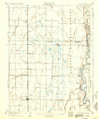
1906 Map of Maxwell
USGS Topo · Published 1936About this map
The Sacramento River defines the eastern boundary of this agricultural landscape at the turn of the century, winding past Boggs Landing and Compton Landing. The river's influence is evident in the complex network of sloughs and bends, such as Packer Slough and Beehive Bend, which contrast with the straight engineered lines of the Central Irrigation Canal further west. In the heart of the valley, the Southern Pacific Railroad connects a string of settlements including Maxwell, Delevan, Norman, and Logandale, reflecting the era's reliance on rail for transporting local produce.
Find a feature on this map
33 named features on this map. Tap any name to fly to it.
Don’t see what you’re looking for? This feature index may not catch every label — zoom into the map to look around manually.
Map Details
Editions of this 1906 Maxwell Map
3 editions found

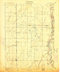
Other maps of this area

1888 · Marysville
USGS Topo · 1:125,000

1891 · Chico
USGS Topo · 1:125,000

1891 · Marysville
USGS Topo · 1:125,000

1893 · Chico
USGS Topo · 1:125,000

1894 · Marysville
USGS Topo · 1:125,000

1895 · Marysville
USGS Topo · 1:125,000

1895 · Chico
USGS Topo · 1:125,000

1904 · Logan Creek
USGS Topo · 1:24,000

1904 · Sites
USGS Topo · 1:24,000

1905 · Fairview
USGS Topo · 1:24,000