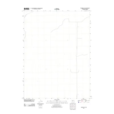
2011 Map of Maxwell NE
USGS Topo · Published 2011About this map
N Maxwell Rd and S Maxwell Rd serve as the primary north-south conduits through this Lincoln County landscape, as mapped by the U.S. Geological Survey in 2011. This specific section of the Maxwell NE quadrangle illustrates the sparse road network characteristic of the Nebraska plains, where few permanent markers exist beyond established rural routes. The map records the area just as digitized mapping standards were evolving, reflecting a transition to the US Topo series. The placement of N Stewart Rd in the northwestern corner highlights the grid-like organization of the region's transportation corridors, which follow the section lines of the Public Land Survey System to manage the vast agricultural and grazing lands of central Nebraska.
Find a feature on this map
3 named features on this map. Tap any name to fly to it.
Don’t see what you’re looking for? This feature index may not catch every label — zoom into the map to look around manually.
Map Details
Editions of this 2011 Maxwell NE Map
This is the sole edition of this map. No revisions or reprints were ever made.
Other maps of this area

1899 · North Platte
USGS Topo · 1:125,000

1902 · North Platte
USGS Topo · 1:125,000

1954 · North Platte
USGS Topo · 1:250,000

1956 · North Platte
USGS Topo · 1:250,000

1957 · North Platte
USGS Topo · 1:250,000

1967 · North Platte
USGS Topo · 1:250,000

1970 · North Platte East
USGS Topo · 1:24,000
1970 · Brady SW
USGS Topo · 1:24,000
1970 · Maxwell
USGS Topo · 1:24,000
1970 · Maxwell SW
USGS Topo · 1:24,000