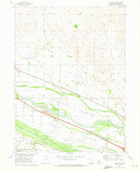
1970 Map of Brady SW
USGS Topo · Published 1973About this map
Old Ft Mc Pherson Military Resv Bdy defines the western edge of this Nebraska landscape, where the braided channels of the Platte River create a complex network of named landforms. Large riverine features like M C C U L L O U G H I S L A N D and B R A D Y I S L A N D are interwoven with smaller features such as Brushy Island and George Island. The arrival of infrastructure is evident in the straight lines of the Union Pacific railroad and the Tri-County Supply Canal, which cut through the natural meandering drainage of Pawnee Creek and Pawnee Slough. Local history is anchored by the Pioneer Sch and the Brady Cem, situated near the rural townships of Maxwell, Brady, and Gaslin. This 1970 snapshot records the area just as Interstate 80 development introduced a modern Rest Area alongside traditional agricultural land and a local Gravel Pit.
Find a feature on this map
28 named features on this map. Tap any name to fly to it.
Don’t see what you’re looking for? This feature index may not catch every label — zoom into the map to look around manually.
Map Details
Editions of this 1970 Brady SW Map
This is the sole edition of this map. No revisions or reprints were ever made.
Other maps of this area

1899 · North Platte
USGS Topo · 1:125,000

1902 · Gothenburg
USGS Topo · 1:125,000

1902 · North Platte
USGS Topo · 1:125,000

1954 · McCook
USGS Topo · 1:250,000

1954 · North Platte
USGS Topo · 1:250,000

1956 · North Platte
USGS Topo · 1:250,000

1956 · Wellfleet NE
USGS Topo · 1:24,000

1957 · North Platte
USGS Topo · 1:250,000

1957 · McCook
USGS Topo · 1:250,000

1958 · McCook
USGS Topo · 1:250,000