
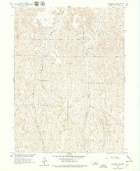
1956 Map of Wellfleet NE
USGS Topo · Published 1974About this map
Upper Box Elder Sch serves as a lone institutional landmark in this corner of Lincoln County, situated among the deeply incised drainage networks of the Missouri River Basin. The landscape is defined by the heavy dissection of high plains terrain, where Box Elder Canyon and Cottonwood Canyon carve significant paths through the upland prairie. These physical features dictated the placement of early infrastructure, as seen in the winding tracks that follow the canyon floors and ridges. The presence of Fox Creek in the southeast and the steep-walled Cut Canyon highlights the geological character of the region during the mid-1950s, a period when rural school districts like the one centered at Upper Box Elder Sch remained vital community anchors before modern consolidation changed the rural educational landscape of Nebraska.
Find a feature on this map
9 named features on this map. Tap any name to fly to it.
Don’t see what you’re looking for? This feature index may not catch every label — zoom into the map to look around manually.
Map Details
Editions of this 1956 Wellfleet NE Map
2 editions found
Other maps of this area

1899 · North Platte
USGS Topo · 1:125,000

1902 · Gothenburg
USGS Topo · 1:125,000

1902 · North Platte
USGS Topo · 1:125,000

1954 · McCook
USGS Topo · 1:250,000

1954 · North Platte
USGS Topo · 1:250,000

1956 · North Platte
USGS Topo · 1:250,000

1956 · Jeffrey Reservoir SW
USGS Topo · 1:24,000

1956 · Wellfleet NW
USGS Topo · 1:24,000

1956 · Wellfleet SE
USGS Topo · 1:24,000

1956 · Wellfleet
USGS Topo · 1:24,000