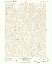
1956 Map of Wellfleet NE
USGS Topo · Published 1979About this map
The branching drainage networks of south-central Lincoln County define this 1956 landscape, where deep erosional features like Box Elder Canyon and Cottonwood Canyon carve through the high plains. The map illustrates a rural Nebraska environment largely shaped by these natural watercourses and the cattle-grazing townships of Payne, Box Elder, and Cottonwood. Settlement is sparse, represented primarily by isolated homesteads and the Upper Box Elder Sch, which served as a focal point for the local ranching community during the mid-20th century.
Find a feature on this map
8 named features on this map. Tap any name to fly to it.
Don’t see what you’re looking for? This feature index may not catch every label — zoom into the map to look around manually.
Map Details
Editions of this 1956 Wellfleet NE Map
2 editions found

Other maps of this area

1899 · North Platte
USGS Topo · 1:125,000

1902 · Gothenburg
USGS Topo · 1:125,000

1902 · North Platte
USGS Topo · 1:125,000

1954 · McCook
USGS Topo · 1:250,000

1954 · North Platte
USGS Topo · 1:250,000

1956 · North Platte
USGS Topo · 1:250,000

1956 · Jeffrey Reservoir SW
USGS Topo · 1:24,000

1956 · Wellfleet NW
USGS Topo · 1:24,000

1956 · Wellfleet SE
USGS Topo · 1:24,000

1956 · Wellfleet
USGS Topo · 1:24,000