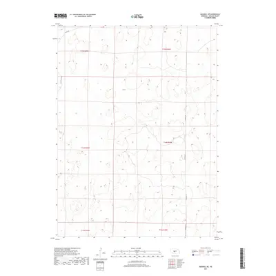
2017 Map of Maxwell NE
USGS Topo · Published 2017About this map
Sandhills terrain and agricultural section lines define this portion of Lincoln County, where the topography transitions into the rhythmic dunes of central Nebraska. The landscape is primarily organized by the Public Land Survey System, with township boundaries such as t14n r28w and t15n r29w demarcating the vast grazing lands. Human infrastructure is sparse and oriented around a few key corridors like N Maxwell Rd and S Maxwell Rd, which serve as the primary north-south conduits through the hills. While the map is dominated by natural depressions and rises, the inclusion of Stewart Rd and E Rolling Hills Rd in the northwestern quadrant indicates the peripheral reach of local ranching and rural access routes during the early 21st century.
Find a feature on this map
10 named features on this map. Tap any name to fly to it.
Don’t see what you’re looking for? This feature index may not catch every label — zoom into the map to look around manually.
Map Details
Editions of this 2017 Maxwell NE Map
This is the sole edition of this map. No revisions or reprints were ever made.
Other maps of this area

1899 · North Platte
USGS Topo · 1:125,000

1902 · North Platte
USGS Topo · 1:125,000

1954 · North Platte
USGS Topo · 1:250,000

1956 · North Platte
USGS Topo · 1:250,000

1957 · North Platte
USGS Topo · 1:250,000

1967 · North Platte
USGS Topo · 1:250,000

1970 · North Platte East
USGS Topo · 1:24,000
1970 · Brady SW
USGS Topo · 1:24,000
1970 · Maxwell
USGS Topo · 1:24,000
1970 · Maxwell SW
USGS Topo · 1:24,000