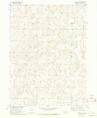
1970 Map of Maxwell NE
USGS Topo · Published 1973About this map
Nebraska's Sandhills terrain dominates this mid-century topographic study, showing a landscape defined by intricate contour patterns and minimal human infrastructure. The area is divided into large precincts including Hall, Cox, and Maxwell, reflecting the rural township structure of Lincoln County during the early 1970s. Aside from the section lines and a few light-duty roads, the most prominent man-made landmark is a Radio Tower located in the southern portion of the quadrangle. This map was produced as part of the Department of the Interior's Missouri River Basin development program, documenting the elevation and drainage patterns of this sparsely populated prairie region before modern industrial or agricultural shifts altered the local geography.
Find a feature on this map
4 named features on this map. Tap any name to fly to it.
Don’t see what you’re looking for? This feature index may not catch every label — zoom into the map to look around manually.
Map Details
Editions of this 1970 Maxwell NE Map
This is the sole edition of this map. No revisions or reprints were ever made.
Other maps of this area

1899 · North Platte
USGS Topo · 1:125,000

1902 · North Platte
USGS Topo · 1:125,000

1954 · North Platte
USGS Topo · 1:250,000

1956 · North Platte
USGS Topo · 1:250,000

1957 · North Platte
USGS Topo · 1:250,000

1967 · North Platte
USGS Topo · 1:250,000

1970 · North Platte East
USGS Topo · 1:24,000
1970 · Brady SW
USGS Topo · 1:24,000
1970 · Maxwell
USGS Topo · 1:24,000
1970 · Maxwell SW
USGS Topo · 1:24,000