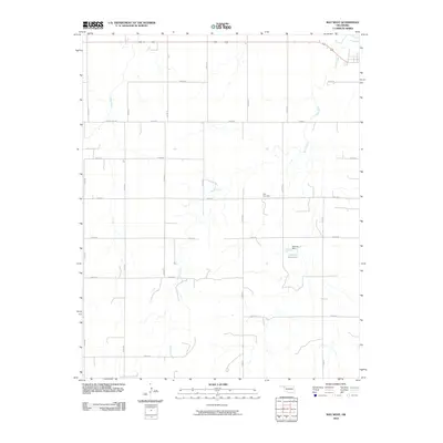
2010 Map of May West
USGS Topo · Published 2010About this map
Otter Creek meanders across this rural section of Harper County, carving a drainage pattern that defines the local topography. This 2010 survey illustrates the organized section-line road system characteristic of the Oklahoma Panhandle region, anchored by the junction of 412 and 270 in the northern portion. The map provides essential documentation for local genealogists, highlighting the location of the May Cemetery east of n1810 RD. Water management is a visible priority in this arid landscape, evidenced by the Doersch Dam and its resulting Doersch Reservoir. The surrounding terrain is primarily accessible via a network of numbered county routes, such as n1770 RD and e0310 RD, which follow the rigid grid of the original land surveys.
Find a feature on this map
22 named features on this map. Tap any name to fly to it.
Don’t see what you’re looking for? This feature index may not catch every label — zoom into the map to look around manually.
Map Details
Editions of this 2010 May West Map
This is the sole edition of this map. No revisions or reprints were ever made.
Other maps of this area

1955 · Woodward
USGS Topo · 1:250,000

1958 · Woodward
USGS Topo · 1:250,000

1969 · Fargo NW
USGS Topo · 1:24,000

1969 · Shattuck NW
USGS Topo · 1:24,000

1969 · Shattuck NE
USGS Topo · 1:24,000

1970 · Laverne SW
USGS Topo · 1:24,000

1971 · May East
USGS Topo · 1:24,000

1971 · Fort Supply NW
USGS Topo · 1:24,000
1971 · Laverne
USGS Topo · 1:24,000

1971 · Laverne NE
USGS Topo · 1:24,000