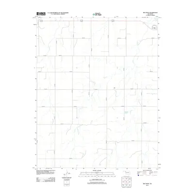
2012 Map of May West
USGS Topo · Published 2012About this map
May sits in the northeastern corner of this landscape, its small grid of streets bounded by May St and Curtis St. The surrounding Harper County terrain is defined by a sparse network of section roads, including Co Line Rd and numerous north-south routes like N1810 Rd, which lead away from the settlement into the open plains. Water is the primary geographic marker here, with the Beaver River cutting through the corner near the town and the winding paths of Otter Cr and Clear Cr stretching across the central and western reaches. Local land use is further evidenced by Doersch Reservoir, a small impoundment in the southeastern quadrant, and the May Cem located just south of the primary settlement. The map provides a high-resolution record of this rural Oklahoma community's footprint in the early twenty-first century.
Find a feature on this map
24 named features on this map. Tap any name to fly to it.
Don’t see what you’re looking for? This feature index may not catch every label — zoom into the map to look around manually.
Map Details
Editions of this 2012 May West Map
This is the sole edition of this map. No revisions or reprints were ever made.
Other maps of this area

1955 · Woodward
USGS Topo · 1:250,000

1958 · Woodward
USGS Topo · 1:250,000

1969 · Fargo NW
USGS Topo · 1:24,000

1969 · Shattuck NW
USGS Topo · 1:24,000

1969 · Shattuck NE
USGS Topo · 1:24,000

1970 · Laverne SW
USGS Topo · 1:24,000

1971 · May East
USGS Topo · 1:24,000

1971 · Fort Supply NW
USGS Topo · 1:24,000
1971 · Laverne
USGS Topo · 1:24,000

1971 · Laverne NE
USGS Topo · 1:24,000