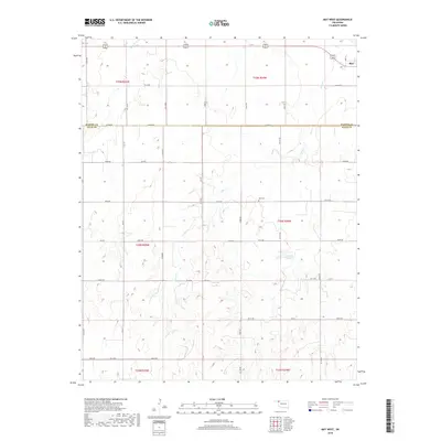
2018 Map of May West
USGS Topo · Published 2018About this map
May sits at the northeastern corner of this western Oklahoma landscape, serving as a primary point of settlement near the transition between t25n r24w and t25n r25w. The terrain is defined by a dense network of sectional roads and the winding drainage of Otter Cr, which flows southward through the center of the sheet. For genealogists and local historians, the May Cem located along e0310 RD provides a critical record of the area's residents. Further south, the Doersch Reservoir indicates the importance of water management in this agricultural region. The map also delineates the jurisdictional boundary between Harper Co and Ellis Co, following the path of Co Line Rd across the high plains. This layout illustrates a late-period rural structure where the grid of county roads, such as NS 177 and Ew 030, remains the backbone of the local economy.
Find a feature on this map
45 named features on this map. Tap any name to fly to it.
Don’t see what you’re looking for? This feature index may not catch every label — zoom into the map to look around manually.
Map Details
Editions of this 2018 May West Map
This is the sole edition of this map. No revisions or reprints were ever made.
Other maps of this area

1955 · Woodward
USGS Topo · 1:250,000

1958 · Woodward
USGS Topo · 1:250,000

1969 · Fargo NW
USGS Topo · 1:24,000

1969 · Shattuck NW
USGS Topo · 1:24,000

1969 · Shattuck NE
USGS Topo · 1:24,000

1970 · Laverne SW
USGS Topo · 1:24,000

1971 · May East
USGS Topo · 1:24,000

1971 · Fort Supply NW
USGS Topo · 1:24,000
1971 · Laverne
USGS Topo · 1:24,000

1971 · Laverne NE
USGS Topo · 1:24,000