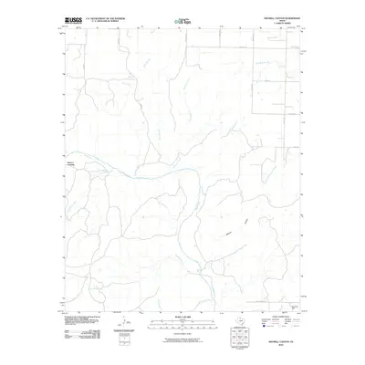
2010 Map of Maybell Canyon
USGS Topo · Published 2010About this map
Pease River dominates this portion of the Hardeman County landscape, carving through the terrain alongside Maybell Canyon. The map reveals a sparse, rural environment defined by an intricate network of waterways including Arkansas Creek, Hog Creek, and Little Cactus Creek. Human imprint is centered on river-crossing points and land management, notably at the Seven L Crossing and the structural presence of Big Pond Dam near the southern boundary. This 2010 survey reflects a period of modern ranching and rural infrastructure, where named roads like Tabor Rd and Wofford Rd provide the primary access through the creek-divided countryside. The confluence of South Fork Wanderers Creek and its parent stream highlights the complex drainage patterns essential to this region of North Texas.
Find a feature on this map
23 named features on this map. Tap any name to fly to it.
Don’t see what you’re looking for? This feature index may not catch every label — zoom into the map to look around manually.
Map Details
Editions of this 2010 Maybell Canyon Map
This is the sole edition of this map. No revisions or reprints were ever made.
Other maps of this area

1927 · Quanah 3-a
USGS Topo · 1:48,000

1927 · Quanah 3-b
USGS Topo · 1:48,000

1932 · Vivian
USGS Topo · 1:62,500

1955 · Lawton
USGS Topo · 1:250,000

1958 · Medicine Mound
USGS Topo · 1:62,500

1960 · Goodlett
USGS Topo · 1:62,500

1960 · Teacup Mountain
USGS Topo · 1:62,500

1960 · Quanah
USGS Topo · 1:62,500

1983 · Big Mound
USGS Topo · 1:24,000
1983 · Margaret
USGS Topo · 1:24,000