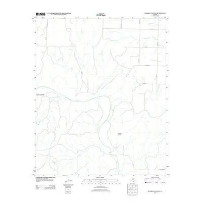
2012 Map of Maybell Canyon
USGS Topo · Published 2012About this map
The Pease River cuts an irregular path across this landscape in Hardeman County, defining a region characterized by deep drainages and intermittent watercourses. At the heart of the area, Maybell Canyon stands as a prominent topographical feature, while the historic Seven L Crossing indicates a traditional point of transit across the riverbed. The drainage network is dense, with numerous named creeks such as Spring Cr, Wanderers Cr, and Little Cactus Cr feeding into the larger river system.
Find a feature on this map
23 named features on this map. Tap any name to fly to it.
Don’t see what you’re looking for? This feature index may not catch every label — zoom into the map to look around manually.
Map Details
Editions of this 2012 Maybell Canyon Map
This is the sole edition of this map. No revisions or reprints were ever made.
Other maps of this area

1927 · Quanah 3-a
USGS Topo · 1:48,000

1927 · Quanah 3-b
USGS Topo · 1:48,000

1932 · Vivian
USGS Topo · 1:62,500

1955 · Lawton
USGS Topo · 1:250,000

1958 · Medicine Mound
USGS Topo · 1:62,500

1960 · Goodlett
USGS Topo · 1:62,500

1960 · Teacup Mountain
USGS Topo · 1:62,500

1960 · Quanah
USGS Topo · 1:62,500

1983 · Big Mound
USGS Topo · 1:24,000
1983 · Margaret
USGS Topo · 1:24,000