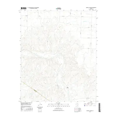
2016 Map of Maybell Canyon
USGS Topo · Published 2016About this map
Maybell Canyon and the wide, braided bed of the Pease River dominate this landscape on the border of Hardeman and Foard counties. The terrain is deeply dissected by numerous watercourses, including the substantial Wanderers Cr and its tributary, S Fork Wanderers Cr, which carve through the plains of North Texas. The settlement pattern is defined by a sparse grid of rural roads, many of which appear to follow section lines or topographical breaks. Named routes such as O'Neal Rd, Tabor Rd, and Wofford Rd provide access across the high ground between drainage basins like Spring Cr and Arkansas Cr. This topographic study reveals the complex drainage network required to move water toward the Pease River during sudden flash events in this semi-arid environment.
Find a feature on this map
23 named features on this map. Tap any name to fly to it.
Don’t see what you’re looking for? This feature index may not catch every label — zoom into the map to look around manually.
Map Details
Editions of this 2016 Maybell Canyon Map
This is the sole edition of this map. No revisions or reprints were ever made.
Other maps of this area

1927 · Quanah 3-a
USGS Topo · 1:48,000

1927 · Quanah 3-b
USGS Topo · 1:48,000

1932 · Vivian
USGS Topo · 1:62,500

1955 · Lawton
USGS Topo · 1:250,000

1958 · Medicine Mound
USGS Topo · 1:62,500

1960 · Goodlett
USGS Topo · 1:62,500

1960 · Teacup Mountain
USGS Topo · 1:62,500

1960 · Quanah
USGS Topo · 1:62,500

1983 · Big Mound
USGS Topo · 1:24,000
1983 · Margaret
USGS Topo · 1:24,000