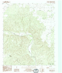
1990 Map of Maybell Canyon
USGS Topo · Published 1995About this map
Pease River cuts through the center of this terrain in north Texas, defining the rugged physical border between Hardeman and Foard counties. The landscape is dominated by a complex network of drainage systems, most notably the deep incisions of Maybell Canyon and the winding course of Wanderers Creek. The presence of Copper Breaks State Park in the southeastern quadrant indicates the preservation of this unique breaks country, where gypsum-capped mesas and red-clay gullies are common. Topographic details reveal numerous named watercourses such as Arkansas Creek, Spring Creek, and Little Cactus Creek, which feed into the primary river valley. An indefinite boundary and the crossing of Xampallia Creek further south mark the transition across the county line into sparsely populated ranching territory.
Find a feature on this map
13 named features on this map. Tap any name to fly to it.
Don’t see what you’re looking for? This feature index may not catch every label — zoom into the map to look around manually.
Map Details
Editions of this 1990 Maybell Canyon Map
This is the sole edition of this map. No revisions or reprints were ever made.
Other maps of this area

1927 · Quanah 3-a
USGS Topo · 1:48,000

1927 · Quanah 3-b
USGS Topo · 1:48,000

1932 · Vivian
USGS Topo · 1:62,500

1955 · Lawton
USGS Topo · 1:250,000

1958 · Medicine Mound
USGS Topo · 1:62,500

1960 · Goodlett
USGS Topo · 1:62,500

1960 · Teacup Mountain
USGS Topo · 1:62,500

1960 · Quanah
USGS Topo · 1:62,500

1983 · Big Mound
USGS Topo · 1:24,000
1983 · Margaret
USGS Topo · 1:24,000