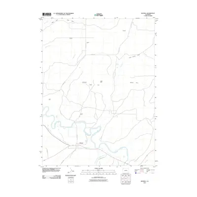
2010 Map of Maybell
USGS Topo · Published 2010About this map
Maybell serves as the central hub of this high-desert landscape in northwestern Colorado, situated where County Rd 19 meets the northern banks of the Yampa River. The area’s industrial character is defined by widespread mineral extraction, with sites like the Maybell Pit and the Hudson Claim Group Mine indicating the historical and ongoing importance of the mining sector. Further exploration of the surrounding draws and hills reveals localized operations such as the Lucky Claim and Trevenen Claims. The management of water in this arid environment is clearly mapped through the winding course of the Maybell Ditch and natural sources like Barber Spring. Landform landmarks including Hat Hill and Eagle Rock overlook the broad basin of Eagle Park, while the Fairview Cemetery north of the main settlement offers a grounded point of reference for genealogists and local historians tracing the families who settled this part of Moffat County.
Find a feature on this map
25 named features on this map. Tap any name to fly to it.
Don’t see what you’re looking for? This feature index may not catch every label — zoom into the map to look around manually.
Map Details
Editions of this 2010 Maybell Map
This is the sole edition of this map. No revisions or reprints were ever made.
Other maps of this area

1907 · White River
USGS Topo · 1:125,000

1910 · Danforth Hills
USGS Topo · 1:125,000

1910 · White River
USGS Topo · 1:125,000

1912 · Axial
USGS Topo · 1:62,500

1914 · Axial
USGS Topo · 1:62,500

1916 · Craig
USGS Topo · 1:125,000

1954 · Vernal
USGS Topo · 1:250,000

1954 · Craig
USGS Topo · 1:250,000

1957 · Craig
USGS Topo · 1:250,000

1958 · Vernal
USGS Topo · 1:250,000