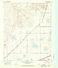
1953 Map of Mayer
USGS Topo · Published 1968About this map
Industrial and agricultural development marks the high plains of Potter County on this 1953 survey, later updated in the late 1960s. The landscape is defined by the intersection of major rail lines, including the Chicago Rock Island and Pacific and the Atchison Topeka and Santa Fe. These transport corridors support local infrastructure like the Grain Elevator at St Francis (Siding) and a Rendering Plant near the settlement of Mayer.
Find a feature on this map
19 named features on this map. Tap any name to fly to it.
Don’t see what you’re looking for? This feature index may not catch every label — zoom into the map to look around manually.
Map Details
Editions of this 1953 Mayer Map
3 editions found
Other maps of this area

1934 · Cliffside
USGS Topo · 1:62,500

1936 · Cliffside
USGS Topo · 1:62,500

1953 · Chunky
USGS Topo · 1:24,000

1953 · Pleasant Valley
USGS Topo · 1:24,000

1953 · Mayer
USGS Topo · 1:24,000

1953 · Pomeroy
USGS Topo · 1:24,000

1953 · Berry Sand Draw
USGS Topo · 1:24,000

1953 · Sevenmile Basin
USGS Topo · 1:24,000

1954 · Amarillo
USGS Topo · 1:250,000

1956 · Amarillo East
USGS Topo · 1:24,000