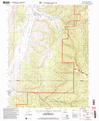
2001 Map of Mayfield
USGS Topo · Published 2004About this map
Mayfield stands at the transition between the agricultural floor of the Arapien Valley and the steep, rising canyons of the Sanpete-Sevier county line. The settlement pattern is defined by the vital flow of Twelvemile Creek, which provides the water source for the South Canal and serves the residential grid of the town. For genealogists and local historians, the Mayfield Cem is clearly plotted on the western outskirts near the White Hills.
Find a feature on this map
27 named features on this map. Tap any name to fly to it.
Don’t see what you’re looking for? This feature index may not catch every label — zoom into the map to look around manually.
Map Details
Editions of this 2001 Mayfield Map
This is the sole edition of this map. No revisions or reprints were ever made.
Other maps of this area

1885 · Manti
USGS Topo · 1:250,000

1885 · Fish Lake
USGS Topo · 1:250,000

1895 · Manti
USGS Topo · 1:250,000

1896 · Fish Lake
USGS Topo · 1:250,000

1956 · Salina
USGS Topo · 1:250,000

1956 · Price
USGS Topo · 1:250,000

1960 · Price
USGS Topo · 1:250,000

1960 · Salina
USGS Topo · 1:250,000

1962 · Salina
USGS Topo · 1:250,000

1962 · Price
USGS Topo · 1:250,000