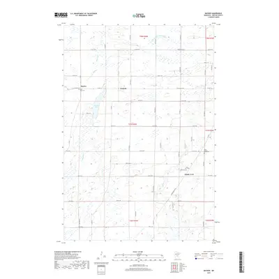
2019 Map of Mayhew
USGS Topo · Published 2019About this map
Mayhew Lake sits as the central hydrologic feature in this portion of Benton County, fed by the waters of Mayhew Cr. The surrounding landscape is defined by its agricultural grid and scattered small settlements, including Mayhew, Fruitville, and Popple Creek. Local genealogy and community history are anchored by several notable burial grounds, such as Saint Marys Cem in the northwest and the Polish Lutheran Church Cem to the east. The terrain is marked by a sophisticated drainage network that includes Sucker Cr and County Ditch Number Seven, reflecting the intensive land management required for Minnesota's rural townships. In the south, the Elk River winds through the landscape near Golden Spike Rd NE, illustrating the transition from local creeks to larger regional river systems.
Find a feature on this map
35 named features on this map. Tap any name to fly to it.
Don’t see what you’re looking for? This feature index may not catch every label — zoom into the map to look around manually.
Map Details
Editions of this 2019 Mayhew Map
This is the sole edition of this map. No revisions or reprints were ever made.
Other maps of this area

1948 · Pierz
USGS Topo · 1:62,500

1950 · Pierz
USGS Topo · 1:62,500

1950 · St. Cloud
USGS Topo · 1:62,500

1953 · Saint Cloud
USGS Topo · 1:250,000

1953 · Stillwater
USGS Topo · 1:250,000

1955 · Stillwater
USGS Topo · 1:250,000

1957 · Saint Cloud
USGS Topo · 1:250,000

1958 · Stillwater
USGS Topo · 1:250,000

1958 · Saint Cloud
USGS Topo · 1:250,000

1965 · Stillwater
USGS Topo · 1:250,000
Featured Places
- Saint George Township, MN
- Gilmanton Township, MN
- Fruitville, MN
- Popple Creek, MN
- Mayhew Lake Township, MN