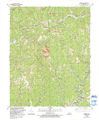
1992 Map of Mayking
USGS Topo · Published 1992About this map
Mayking and its surrounding coal-country settlements define this corner of Letcher County during the early 1990s. The map illustrates a landscape shaped by narrow valleys and industrial extraction, where numerous Mine and Strip Mine sites are cut into the terrain above the North Fork Kentucky River. Community life is anchored by a network of rural churches and cemeteries, including Sandlick Ch, Camp Branch Chapel, and Little Colly Ch. Transportation follows the winding creek beds, with CSX Transportation rails and routes like KY 15 threading through gaps such as Logan Gap and Thornton Gap. Notable local infrastructure like the Whitesburg Municipal Airport and several substations serve the dispersed residential centers of Millstone, Sergent, and Colson. The northern reaches include the border with Knott County, marked by the flow of Rockhouse Creek near the town of Deane.
Find a feature on this map
47 named features on this map. Tap any name to fly to it.
Don’t see what you’re looking for? This feature index may not catch every label — zoom into the map to look around manually.
Map Details
Editions of this 1992 Mayking Map
This is the sole edition of this map. No revisions or reprints were ever made.
Other maps of this area

1890 · Whitesburg
USGS Topo · 1:125,000

1892 · Whitesburg
USGS Topo · 1:125,000

1912 · Pound
USGS Topo · 1:48,000

1912 · Hindman
USGS Topo · 1:48,000

1913 · Oven Fork
USGS Topo · 1:48,000

1914 · Pound
USGS Topo · 1:62,500

1914 · Vergie
USGS Topo · 1:48,000

1915 · Hindman
USGS Topo · 1:62,500

1915 · Whitesburg
USGS Topo · 1:62,500

1916 · Pikeville
USGS Topo · 1:62,500