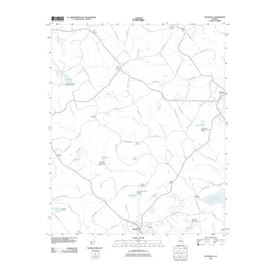
2011 Map of Maysville
USGS Topo · Published 2011About this map
Maysville and Homer anchor this 2011 survey of the northeast Georgia landscape, where the headwaters of the Hudson River and Grove Creek are managed by a series of flood control structures. The map is particularly rich in genealogical data, preserving the locations of numerous family and community burial grounds including Hickory Flat Cemetery, Mount Carmel Cemetery, and the Veal Cemetery near Maysville. The terrain is defined by the winding paths of Hickory Level Creek and Candler Creek, with local infrastructure marked by historical crossings such as Savill Bridge, Ryles Bridge, and Mangum Bridge. This modern topographic study illustrates a rural corridor where legacy land boundaries and small cemeteries remain central to the geography even as water management projects like Reservoir 51 and Reservoir 30 have reshaped the local drainage patterns.
Find a feature on this map
83 named features on this map. Tap any name to fly to it.
Don’t see what you’re looking for? This feature index may not catch every label — zoom into the map to look around manually.
Map Details
Editions of this 2011 Maysville Map
This is the sole edition of this map. No revisions or reprints were ever made.
Other maps of this area

1891 · Gainesville
USGS Topo · 1:125,000

1891 · Carnesville
USGS Topo · 1:125,000

1954 · Greenville
USGS Topo · 1:250,000

1958 · Greenville
USGS Topo · 1:250,000

1964 · Commerce
USGS Topo · 1:24,000

1964 · Maysville
USGS Topo · 1:24,000

1964 · Lula
USGS Topo · 1:24,000
1964 · Lake Russell
USGS Topo · 1:24,000

1964 · Pendergrass
USGS Topo · 1:24,000
1964 · Baldwin
USGS Topo · 1:24,000