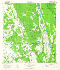
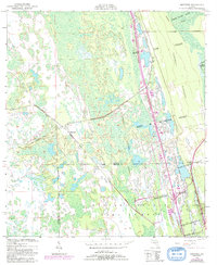
1950 Map of Maytown
USGS Topo · Published 1964About this map
The Florida East Coast rail corridor bisects a landscape defined by expansive Spanish land grants and wetland terrain on the boundary between Volusia and Brevard Counties. This 1950 survey, based on 1948 aerial photography, details the isolated settlement of Maytown at a critical rail junction. To the southeast, the community of Scottsmoor sits near the edge of the Brevard County Game Refuge. Much of the map's eastern half is occupied by massive historical tracts including the Joseph Wales Grant and the Delespine Grant, reflecting the colonial-era partitioning of this coastal region. The presence of an Old Railroad Grade and the elevated terrain of Turnbull Hummock suggest the early twentieth-century attempts to navigate and utilize these low-lying Florida marshes.
Find a feature on this map
14 named features on this map. Tap any name to fly to it.
Don’t see what you’re looking for? This feature index may not catch every label — zoom into the map to look around manually.
Map Details
Editions of this 1950 Maytown Map
6 editions found
Other maps of this area

1949 · Oak Hill
USGS Topo · 1:24,000

1949 · Mims
USGS Topo · 1:24,000

1949 · Osceola
USGS Topo · 1:24,000

1950 · Maytown
USGS Topo · 1:24,000

1950 · Ariel
USGS Topo · 1:24,000

1950 · Edgewater
USGS Topo · 1:24,000

1950 · Aurantia
USGS Topo · 1:24,000

1952 · Mims
USGS Topo · 1:24,000

1953 · Geneva
USGS Topo · 1:24,000

1955 · Orlando
USGS Topo · 1:250,000