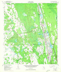
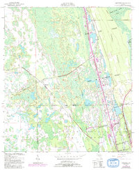
1950 Map of Maytown
USGS Topo · Published 1972About this map
The Maytown settlement and surrounding wetlands define this mid-century landscape on the border of Volusia and Brevard counties. Large colonial-era land grants, including the Joseph Wales Grant and Delespine Grant, divide the terrain into massive geometric blocks that supersede the standard section lines. These grants are interspersed with dedicated conservation areas like the John H McIntosh Game Refuge and the Volusia Co Game Refuge, illustrating a region transitioning from historic private holdings to state-managed wildlife habitats. Transportation is dominated by the Florida East Coast corridor, while an Old Railroad Grade and the rising elevation of Turnbull Hummock provide evidence of earlier land use and timber or agricultural activity. In the southeast, the small community of Scottsmoor sits at the edge of the Bernardo Segui Grant, anchoring the rail line as it moves south.
Find a feature on this map
15 named features on this map. Tap any name to fly to it.
Don’t see what you’re looking for? This feature index may not catch every label — zoom into the map to look around manually.
Map Details
Editions of this 1950 Maytown Map
6 editions found
Other maps of this area

1949 · Oak Hill
USGS Topo · 1:24,000

1949 · Mims
USGS Topo · 1:24,000

1949 · Osceola
USGS Topo · 1:24,000

1950 · Maytown
USGS Topo · 1:24,000

1950 · Ariel
USGS Topo · 1:24,000

1950 · Edgewater
USGS Topo · 1:24,000

1950 · Aurantia
USGS Topo · 1:24,000

1952 · Mims
USGS Topo · 1:24,000

1953 · Geneva
USGS Topo · 1:24,000

1955 · Orlando
USGS Topo · 1:250,000