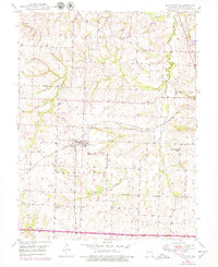
1949 Map of Mayview
USGS Topo · Published 1979About this map
The agricultural and industrial landscapes of Lafayette County converge near Mayview, where the Gulf Mobile and Ohio railroad corridor serves as the primary axis for local commerce. This survey reflects the mid-century transition of rural Missouri, documenting a territory punctuated by local landmarks such as Mayview Cemetery and several country schools including Elm Grove School and Wheatly School. Evidence of resource extraction is clear from the numerous Strip Mines and a prominent Mine Dump located just outside the village. The drainage patterns of Brush Creek, Tabo Creek, and Garrison Creek define the township boundaries of Lexington, Washington, and Davis, illustrating the relationship between the area's hydrology and its historical land divisions.
Find a feature on this map
20 named features on this map. Tap any name to fly to it.
Don’t see what you’re looking for? This feature index may not catch every label — zoom into the map to look around manually.
Map Details
Editions of this 1949 Mayview Map
2 editions found
Other maps of this area

1885 · Warrensburg
USGS Topo · 1:125,000

1887 · Warrensburg
USGS Topo · 1:125,000

1889 · Lexington
USGS Topo · 1:125,000

1894 · Warrensburg
USGS Topo · 1:125,000

1917 · Knobnoster
USGS Topo · 1:62,500

1947 · Jefferson City
USGS Topo · 1:250,000

1949 · Mayview
USGS Topo · 1:24,000

1949 · Lexington East
USGS Topo · 1:24,000

1949 · Lexington West
USGS Topo · 1:24,000

1949 · Odessa North
USGS Topo · 1:24,000