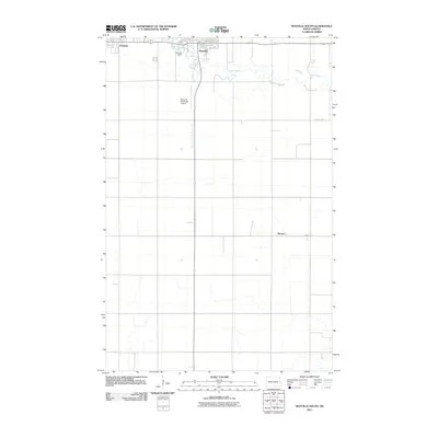
2011 Map of Mayville South
USGS Topo · Published 2011About this map
Mayville and its neighbor Portland anchor the northern edge of this Traill County landscape, where the meandering Goose River carves a winding path through the flat agricultural plains. The river's flow is regulated by the Mayville Dam, situated near the edge of the town center. The surrounding region is defined by a rigid grid of rural roads and drainage infrastructure, such as Mayville Drain Number 19, which manages the water levels across the expansive farmland. To the south, the small community of Murray sits along County Hwy-11, serving as a quiet waypoint in this productive corner of the Red River Valley. The Mayville Municipal Airport provides a key transportation link for the area, while local thoroughfares like Jahr Ave and Main St W define the early 21st-century footprint of these historic prairie settlements.
Find a feature on this map
19 named features on this map. Tap any name to fly to it.
Don’t see what you’re looking for? This feature index may not catch every label — zoom into the map to look around manually.
Map Details
Editions of this 2011 Mayville South Map
This is the sole edition of this map. No revisions or reprints were ever made.
Other maps of this area

1918 · Kelso
USGS Topo · 1:62,500

1943 · Kelso
USGS Topo · 1:62,500

1952 · Grand Forks
USGS Topo · 1:250,000

1956 · Grand Forks
USGS Topo · 1:250,000

1966 · Grand Forks
USGS Topo · 1:250,000

1966 · Galesburg
USGS Topo · 1:24,000

1967 · Mayville South
USGS Topo · 1:24,000

1967 · Blanchard
USGS Topo · 1:24,000
1967 · Hillsboro NW
USGS Topo · 1:24,000
1968 · Galesburg
USGS Topo · 1:24,000