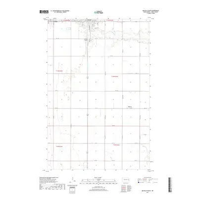
2017 Map of Mayville South
USGS Topo · Published 2017About this map
Goose River meanders through the northern section of this Traill County landscape, passing just south of Mayville and Portland. The terrain is characterized by a high concentration of drainage systems and agricultural sections, including Mayville Drain Number 1 and Hanson Drain. This 2017 survey reveals the established infrastructure of the Red River Valley, with a dense grid of township roads such as 152nd Ave NE and Center St connecting the rural expanse. The Mayville Municipal Airport sits on the western edge of Mayville, serving as a modern local landmark. Further south, the settlement of Murray appears as a small node within the grid, highlighting the persistent pattern of small-town development and regional connectivity through routes like Co Hwy 13 and Co Hwy 11.
Find a feature on this map
44 named features on this map. Tap any name to fly to it.
Don’t see what you’re looking for? This feature index may not catch every label — zoom into the map to look around manually.
Map Details
Editions of this 2017 Mayville South Map
This is the sole edition of this map. No revisions or reprints were ever made.
Other maps of this area

1918 · Kelso
USGS Topo · 1:62,500

1943 · Kelso
USGS Topo · 1:62,500

1952 · Grand Forks
USGS Topo · 1:250,000

1956 · Grand Forks
USGS Topo · 1:250,000

1966 · Grand Forks
USGS Topo · 1:250,000

1966 · Galesburg
USGS Topo · 1:24,000

1967 · Mayville South
USGS Topo · 1:24,000

1967 · Blanchard
USGS Topo · 1:24,000
1967 · Hillsboro NW
USGS Topo · 1:24,000
1968 · Galesburg
USGS Topo · 1:24,000