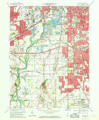
1967 Map of Maywood
USGS Topo · Published 1969About this map
The White River corridor dominates this late-1960s landscape, serving as a backdrop for the industrial and residential expansion south of the Indianapolis city center. The western edge is defined by the Penn Central rail lines and the busy corridor of Kentucky Ave, while the Union Stockyards and various Gravel Pits highlight the era's heavy commerce. Residential pockets like Drexel Gardens, Mars Hill, and Sunshine Gardens are interspersed with significant institutions, including Indiana Central College and the University Heights Hospital.
Find a feature on this map
86 named features on this map. Tap any name to fly to it.
Don’t see what you’re looking for? This feature index may not catch every label — zoom into the map to look around manually.
Map Details
Editions of this 1967 Maywood Map
3 editions found
Other maps of this area

1948 · Indianapolis East
USGS Topo · 1:24,000

1948 · Maywood
USGS Topo · 1:24,000

1948 · Beech Grove
USGS Topo · 1:24,000

1948 · Indianapolis West
USGS Topo · 1:24,000

1952 · Bargersville
USGS Topo · 1:24,000

1953 · Greenwood
USGS Topo · 1:24,000

1953 · Bridgeport
USGS Topo · 1:24,000

1953 · Clermont
USGS Topo · 1:24,000

1953 · Indianapolis
USGS Topo · 1:250,000

1955 · Mooresville East
USGS Topo · 1:24,000
Featured Places
- Indianapolis, IN
- Greenwood, IN
- Southport, Indianapolis
- Homecroft, Indianapolis
- Drexel Gardens, Indianapolis