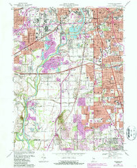
1967 Map of Maywood
USGS Topo · Published 1987About this map
White River frontage and industrial corridors define this mid-century look at the southern reaches of Marion County. The Union Stockyards and various Gravel Pits illustrate the heavy commercial activity of the era, while the sprawling campus of Indiana Central College anchors the University Heights neighborhood. Residential expansion is evident in neighborhoods like Sunshine Gardens and Lindenwood, where post-war growth begins to bridge the gap between traditional farmsteads and the urban core.
Find a feature on this map
86 named features on this map. Tap any name to fly to it.
Don’t see what you’re looking for? This feature index may not catch every label — zoom into the map to look around manually.
Map Details
Editions of this 1967 Maywood Map
3 editions found
Other maps of this area

1948 · Indianapolis East
USGS Topo · 1:24,000

1948 · Maywood
USGS Topo · 1:24,000

1948 · Beech Grove
USGS Topo · 1:24,000

1948 · Indianapolis West
USGS Topo · 1:24,000

1952 · Bargersville
USGS Topo · 1:24,000

1953 · Greenwood
USGS Topo · 1:24,000

1953 · Bridgeport
USGS Topo · 1:24,000

1953 · Clermont
USGS Topo · 1:24,000

1953 · Indianapolis
USGS Topo · 1:250,000

1955 · Mooresville East
USGS Topo · 1:24,000
Featured Places
- Indianapolis, IN
- Greenwood, IN
- Southport, Indianapolis
- Homecroft, Indianapolis
- Drexel Gardens, Indianapolis