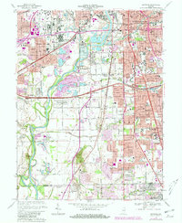
1967 Map of Maywood
USGS Topo · Published 1981About this map
The White River and Eagle Creek dominate the landscape of southern Indianapolis during a period of significant suburban expansion and industrial transition. To the north, the Union Stockyards and a complex network of Conrail lines highlight the area's role as a major regional hub for commerce and transport. The map captures the footprint of Indiana Central College and the green space of Garfield Park amidst a tightening grid of residential developments like University Heights and Drexel Gardens.
Find a feature on this map
92 named features on this map. Tap any name to fly to it.
Don’t see what you’re looking for? This feature index may not catch every label — zoom into the map to look around manually.
Map Details
Editions of this 1967 Maywood Map
3 editions found
Other maps of this area

1948 · Indianapolis East
USGS Topo · 1:24,000

1948 · Maywood
USGS Topo · 1:24,000

1948 · Beech Grove
USGS Topo · 1:24,000

1948 · Indianapolis West
USGS Topo · 1:24,000

1952 · Bargersville
USGS Topo · 1:24,000

1953 · Greenwood
USGS Topo · 1:24,000

1953 · Bridgeport
USGS Topo · 1:24,000

1953 · Clermont
USGS Topo · 1:24,000

1953 · Indianapolis
USGS Topo · 1:250,000

1955 · Mooresville East
USGS Topo · 1:24,000
Featured Places
- Indianapolis, IN
- Greenwood, IN
- Southport, Indianapolis
- Homecroft, Indianapolis
- Drexel Gardens, Indianapolis