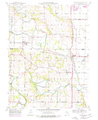
1949 Map of Maywood
USGS Topo · Published 1977About this map
North Fabius River and South Fabius River define the undulating landscape of northeast Missouri in this mid-century survey, which reveals a rural fabric centered on the settlement of Maywood. The area is densely mapped with community institutions, including several rural education sites such as Shannon Sch, Oakview Sch, and Franklin Sch, alongside the Olivet Ch. These landmarks, paired with numerous cemeteries like Maywood Cem and Sunrise Cem, offer a detailed view of the region's genealogical and social footprint before later developments.
Find a feature on this map
28 named features on this map. Tap any name to fly to it.
Don’t see what you’re looking for? This feature index may not catch every label — zoom into the map to look around manually.
Map Details
Editions of this 1949 Maywood Map
2 editions found
Other maps of this area

1903 · Kahoka
USGS Topo · 1:125,000

1903 · Palmyra
USGS Topo · 1:125,000

1925 · Quincy
USGS Topo · 1:62,500

1944 · Quincy
USGS Topo · 1:62,500

1945 · Quincy
USGS Topo · 1:62,500

1946 · Mendon
USGS Topo · 1:62,500

1948 · Quincy
USGS Topo · 1:250,000

1948 · Mendon
USGS Topo · 1:62,500

1949 · Durham
USGS Topo · 1:24,000

1949 · Maywood
USGS Topo · 1:24,000