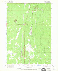
1967 Map of Mazama
USGS Topo · Published 1970About this map
Mazama and Yamsay sit along the corridor of the Southern Pacific railroad in this late 1960s survey of Klamath County. The landscape is defined by its transition from volcanic features like Buckeye Butte and a prominent Cinder Pit to the arid expanse of the Antelope Desert. This specific map reveals the historical demarcations of the high country, most notably the Old Indian Treaty Boundary crossing the rail line near Diamond Lake Junction. The local infrastructure of the era is remarkably lean, centered on a large industrial Pipeline and seasonal watercourses such as Silent Creek, Sink Creek, and Desert Creek. For those studying the evolution of land use in southern Oregon, the presence of a remote Landing Strip and a cluster of rail-side service points provides a rare look at the area's mid-century logistics.
Find a feature on this map
19 named features on this map. Tap any name to fly to it.
Don’t see what you’re looking for? This feature index may not catch every label — zoom into the map to look around manually.
Map Details
Editions of this 1967 Mazama Map
This is the sole edition of this map. No revisions or reprints were ever made.
Other maps of this area

1889 · Klamath
USGS Topo · 1:250,000

1894 · Klamath
USGS Topo · 1:250,000

1935 · Chemult
USGS Topo · 1:96,000

1941 · Chemult
USGS Topo · 1:125,000

1955 · Crescent
USGS Topo · 1:250,000

1955 · Klamath Falls
USGS Topo · 1:250,000

1957 · Crescent
USGS Topo · 1:250,000

1957 · Klamath Marsh
USGS Topo · 1:62,500

1957 · Lenz
USGS Topo · 1:62,500

1958 · Crescent
USGS Topo · 1:250,000