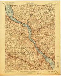
1912 Map of Mc Calls Ferry
USGS Topo · Published 1918About this map
The Susquehanna River carves a deep path through Lancaster and York counties, serving as the dominant geographic and industrial artery for the region. Along its banks, the transition from older transport methods to modern infrastructure is evident. The Tidewater Canal (Abandoned) runs parallel to the water, superseded by the Pennsylvania RR and its numerous river-side stops such as Shenks Ferry Sta and York Furnace Sta. The local economy of the early 1910s is anchored by river power and iron history, seen at the Power Plant near McCalls Ferry & Holtwood P O and the established Martic Forge. Inland, the landscape is dotted with a dense network of civic foundations, including the Mylin School, Bethesda Church, and small milling operations like Eros Mill along Tucquan Creek.
Find a feature on this map
130 named features on this map. Tap any name to fly to it.
Don’t see what you’re looking for? This feature index may not catch every label — zoom into the map to look around manually.
Map Details
Editions of this 1912 Mc Calls Ferry Map
5 editions found

Other maps of this area

1900 · Havre De Grace
USGS Topo · 1:62,500

1900 · Parkton
USGS Topo · 1:62,500

1901 · Belair
USGS Topo · 1:62,500

1902 · Parkton
USGS Topo · 1:62,500

1902 · Lancaster
USGS Topo · 1:62,500

1904 · Lancaster
USGS Topo · 1:62,500

1906 · New Holland
USGS Topo · 1:62,500

1908 · Middletown
USGS Topo · 1:62,500

1908 · New Holland
USGS Topo · 1:62,500

1908 · York
USGS Topo · 1:62,500
Featured Places
- West Lampeter Township, PA
- Willow Street, West Lampeter Township
- Millersville, PA
- Pequea, Conestoga Township
- Conestoga Township, PA